English-language version of Luistxo Fernandez's blog
Tagzania, folksonomy meets Google Maps
After playing with Google Maps for the San Fermin running of the Bulls trick (it even got a mention at Der Spiegel in Germany!), now a more serious application:
We call it Tagzania.
Folksonomy like at del.icio.us of Flickr, but applied to maps. Tagzania follows the del.icio.us model but instead of URL locations, you save geographic locations and then see them plotted in maps: your own maps, or shared ones (by tags).
Social software meets Google Maps. That's the intention. We'll see if the idea catches.
Tagzania has also its blog. It will be probably me, Luistxo, who will write there most of time, with this broken english of mine. Probably the English side of the Cemetery will be more silent from now on.
The first blog out there to spot Tagzania has been Jay Knight's. His praise litfs my spirit today. Word of mouth is the chance to get users and see the application flourish.
Running of the Bulls in Pamplona Googlemapped
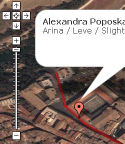
Following the sad news from London, today's not the best day to show a map with injured people plotted in it. But well, this is what we made this morning before we got the news: the San Fermin map, as today is the San Fermin day, 7th of July.

It's a multitude event in Spain, the running of the Bulls at San Fermin Festival in Pamplona. Today it was the first running, the first encierro. We will add everyday's chronicle for a week. Check http://www.codesyntax.com/proiektuak/sanfermin.html
We're working in more dynamic and interesting developments and hope to share those with you in the near future. The San Fermin gmap is just a showcase.
We believe that usage of GoogleMaps to ilustrate news will be ground for intense development and fruitful ideas. Sometimes it will be sad news that will be plotted into the maps. Hopefully, there will be occasions to use the maps for more joyful reasons.

